
Zion Narrows: the complete hiking guide
A full trip-planning guide to The Narrows in Zion National Park, Utah — covering both route options, best seasons, shuttle & parking strategy, frontcountry and backcountry camping, and four signature photography spots.

Somewhere around mile two, the canyon walls close in to 20 feet across, sandstone towers a thousand feet overhead, and the Virgin River runs cold around your knees. That moment — the one photographers chase and hikers talk about for years — is what The Narrows delivers. It is also completely reproducible if you plan the logistics right.
This guide covers everything needed to execute the trip: the two route options, when to go based on water levels and crowds, how to navigate the shuttle system without spending your morning in a parking queue, camping on both ends of the experience spectrum, the four spots that produce the photographs, and the gear that separates a great day from a soggy disaster.
A hiker in The Narrows — the canyon walls rise over 1,000 ft 1
Trail profile
Location: Zion National Park, Utah. The trailhead for the most popular approach — the bottom-up day hike — is at Temple of Sinawava, Shuttle Stop 9 at the north end of Zion Canyon Scenic Drive.
Bottom-up day hike (no permit required)
This is the accessible version and the right choice for the overwhelming majority of visitors. From the shuttle stop, a paved Riverside Walk leads one mile north before the pavement ends and the river begins. From that wade-in point, hikers travel upstream through the river itself — on, between, and around wet boulders — to Big Springs at 4.7 miles from the trailhead, the mandatory turnaround for day hikers. 2
- Total distance: 9.4 miles round trip (15.1 km)
- Elevation gain: 334 feet (102 m)
- Time: 1–8 hours depending on how far up hikers travel
- Difficulty: Moderately strenuous to strenuous — the river bottom is slick, rounded boulders; Joe Braun of Joe's Guide to Zion describes the footing as "trying to walk on greased bowling balls." 3
- Permit: None required
Key waypoints: Mystery Falls (under 0.5 mi from wade-in) → Wall Street begins (~2 mi, canyon narrows to 20–30 ft wide, walls reach 1,000 ft) → Orderville Canyon junction (~2.5 mi) → Big Springs (~4.7 mi, turnaround). At least 60% of hiking time is spent in the water. 2
Top-down through-hike (permit required)
The full Narrows runs from Chamberlain's Ranch to Temple of Sinawava — 16 miles by NPS measurement, or 18 miles by Joe's Guide (which includes the dirt-road approach to the ranch trailhead). 4 5 Elevation drops 1,300–1,500 feet across the route. A fit single-day push takes 10–14 hours; the standard approach is two days with one overnight inside the canyon. This version requires a Wilderness Permit (covered under camping below), and at least 80% of travel is through the river. Chamberlain's Ranch sits on a dirt road that private cars can reach in normal conditions; Springdale-based shuttle services offer drop-offs.
Water, weather, and when to go
Timing a Narrows trip involves two independent variables: CFS (cubic feet per second), which determines whether the hike is even open, and crowds + seasonal conditions, which determine whether it's enjoyable.
CFS thresholds
The NPS closes The Narrows when the Virgin River flow exceeds these levels: 6
| Route | Closure threshold |
|---|---|
| Bottom-up day hike | 150 CFS |
| Top-down (permits suspended) | 120 CFS |
Below 70 CFS, water depth is generally knee-deep and manageable. Between 70–150 CFS, sections reach mid-thigh or higher and current is strong. The park also closes immediately when the National Weather Service issues a flash flood warning, reopening two hours after the warning is lifted. 1
A Reddit trip report from the 2026 Memorial Day weekend recorded roughly 45 CFS — easy conditions. The deepest water on that day reached the rib cage of a 5'3" hiker. 7 For current conditions before any trip, check the USGS monitoring station 09405500 (Virgin River near Springdale) and the NPS current conditions page. 8
Blue-green algae warning: Zion biologists have detected toxic blue-green algae in the Virgin River and its tributaries. Drinking river water or submerging your head is not permitted. Standard recreational water filters do not neutralize the toxins. 1
Season by season
Spring (March–May): The Narrows is frequently closed during spring snowmelt. Historical closure windows: April 9–May 18 in 2020; April 8–June 19 in 2023 (an unusually long closure); April 11–May 19 in 2024. High-snowpack years have kept the canyon closed until mid-July. 3 Check conditions before booking any spring trip.
Summer (June–September): The most popular window. Water temperatures reach 56–68°F (13–20°C) and the narrow canyon channels direct sunlight for midday photography. But air temperatures frequently top 100°F (38°C), monsoon season runs July through September bringing flash flood risk, and crowds are relentless. 6
Fall (September–November): The window photographers and experienced hikers consistently recommend. Water stabilizes well below closure thresholds by October. Canyon maple trees turn orange and yellow in late October. Light stays warm and soft throughout the day. Matt Purciel, a landscape photographer who has documented The Narrows extensively, names late October to early November as "the sweet spot — crowds are down, water is at safe levels, the light is excellent, and the canyon maples show off their fall colors." Jeff Stamer of Firefall Photography agrees: "fall and winter are ideal — water levels are lower and the current is much reduced making your footing easier." 9 10 The trade-off is cooler water: 41–53°F (5–12°C) in spring and fall, requiring neoprene socks or pants. 6
Winter (December–February): A different experience altogether — ice formations on canyon walls, thin crowds, and an otherworldly stillness. Full wetsuit or drysuit gear is required. The NPS does not issue single-day top-down permits in winter due to limited daylight.
Getting there: parking and shuttle
The bottom-up trailhead is Temple of Sinawava, at the end of Zion Canyon Scenic Drive. During shuttle season (roughly March through November), private vehicles are not permitted on Scenic Drive — with the exception of Zion Lodge guests — so the shuttle is the only way in.
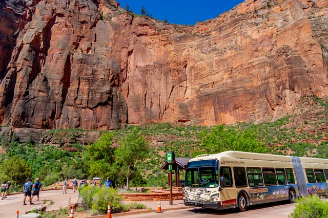
Canyon shuttle schedule
| Period | First shuttle from Visitor Center | Last shuttle from Temple of Sinawava |
|---|---|---|
| May 17–Sep 12 | 7:00 AM | 8:15 PM |
| Sep 13–Oct 24 | 7:00 AM | 7:15 PM |
| Oct 25–Nov 28 | 7:00 AM | 6:15 PM |
Shuttles run every 5–10 minutes and are free. A separate Springdale Line connects downtown Springdale to the park entrance, running 8:00 AM–8:00 PM during peak season. 11
Do not cut the last shuttle close. The NPS explicitly warns: "If the last shuttle is full, or if you miss the last shuttle, you may have to walk nine miles back to the Zion Canyon Visitor Center." 11
Parking reality
The Visitor Center lot fills fast. On the 2026 Memorial Day weekend, the lot was nearly full by 6:50 AM Saturday and completely full by 6:50 AM Sunday. On Sunday morning, shuttle lines ran 90 minutes long by 7:30 AM. 7 Arriving 30–45 minutes before the first shuttle departs is the practical minimum on busy days; 45+ minutes on holiday weekends.
Alternatives if the Visitor Center lot is full:
- Springdale street parking: approximately $25/day
- Springdale private lots: approximately $60/day
- E-bike: Springdale rental shops offer e-bikes that can legally travel Scenic Drive (unlike the shuttle, e-bikes do not require waiting in queue). Visitors on the 2026 Memorial Day weekend consistently described e-bikes as the better option on congested days. 7
Driving distance: Las Vegas is approximately 2.5 hours; Salt Lake City is approximately 4.5 hours.
Camping
Frontcountry
Watchman Campground sits near the South Entrance and is open year-round. All sites require advance reservation through recreation.gov — standard sites book up to six months ahead. There is no walk-up availability. The campground is exposed, with limited shade, and daily summer highs regularly exceed 95°F (35°C). 12
South Campground is closed indefinitely for full renovation as of May 2026. 13
Lava Point Campground sits higher on Kolob Terrace Road, about an hour's drive from Zion Canyon. Cooler temperatures, more shade, and seasonal availability (typically summer and fall). Reservations open 14 days in advance through recreation.gov. 13
Backcountry (Narrows overnight)
Top-down backpackers camp at one of 12 designated sites inside the canyon, distributed roughly between Chamberlain's Ranch and the midpoint near Goose Creek. Sites are named and numbered (Deep Creek, River Bend, Right Bench, Flat Rock, Ringtail, Kolob Creek, Box Elder, Boulder Camp, Left Bench, West Bend, Spotted Owl, High Camp). 5
Permit fees: $20 per permit + $7 per person per night, booked through recreation.gov. 14 Availability opens through advance reservations (months ahead) and a daily lottery two days before the hike date — any unclaimed spots from the advance pool release as walk-up the day before. The NPS Wilderness Permit page notes: "Wilderness Permits do not provide a safety net — you are responsible for your personal safety." 14
All solid human waste must be packed out. Pack-out bags (Restop 2 or Cleanwaste GO) are available from Springdale outfitters.
Signature photography spots
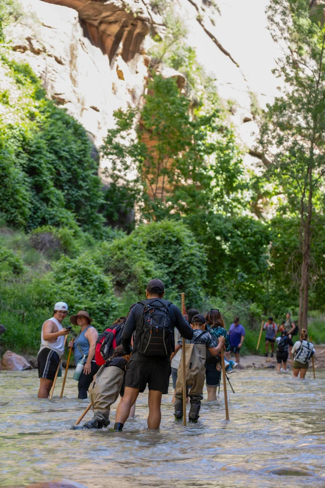
Wall Street (~2–3.5 mi from trailhead)
The canyon pinches to 20–30 feet across here, with walls rising 1,000–1,500 feet. The defining Narrows photograph happens when direct sunlight penetrates the slot at midday, igniting the sandstone in warm amber. Matt Purciel describes that light: "There is a moment, somewhere deep in the Zion Narrows, when the canyon walls close in around you, the cold Virgin River rushes past your legs, and a shaft of warm amber light ignites the sandstone above your head. Time stops." 9
Floating Rock / House Rock sits in the river within Wall Street — set the tripod as low as possible, use a slow shutter (1/4–2 seconds) at f/11–f/14, ISO 100, and a polarizing filter to cut surface glare. Do not overcorrect white balance toward cooler tones — the warm amber cast is the shot.
Orderville Canyon junction (~2.5 mi)
The side canyon branching right is darker, narrower, and more atmospheric than the main Narrows. Veiled Falls, a small cascade inside Orderville, is the signature subject here. Bottom-up hikers may explore only 0.25 miles into Orderville; deeper access requires a canyoneering permit. Jeff Stamer recommends showing minimal sky: "Only show a sliver of sky (or none at all) in your shots. If you include large portions of the sky, it will be difficult to prevent it from overpowering the rest of your image." 10
Mystery Falls (<0.5 mi from wade-in)
Water seeps and cascades from a crack in the sandstone wall. Accessible early in the hike and best in morning light before the canyon fills with foot traffic. The intimate scale of this spot rewards wide-angle compositions with a hiking figure for scale.
Big Springs (~4.7 mi, turnaround)
A series of seeps and small waterfalls emerge directly from the canyon walls, feeding the river. This is the mandatory turnaround for bottom-up day hikers and marks roughly four hours of hiking from the trailhead at a moderate pace. Plan a 15–20 minute stop here.
Technique summary: tripod is essential throughout — the canyon floor allows no stable handheld shots in moving water. Bring a rain sleeve or waterproof housing for the camera body; the river is not optional. Drones are prohibited in all US national parks without a special-use permit. 1
Gear essentials
The single most important piece of equipment for The Narrows is footwear. NPS ranger Jonathan Fortner: "Every hiker in The Narrows should have closed toed shoes, even just your regular hiking boots, and a walking stick." 1 The NPS safety page reinforces this bluntly: "Sandals, crocs, and bare feet are not appropriate. Inappropriate footwear often results in twisted ankles and crushed toes." 6
| Item | Notes |
|---|---|
| Closed-toe shoes | Hiking boots preferred; trail runners acceptable |
| Trekking pole(s) | Balance and depth-testing; one pole is the minimum |
| Dry bag | For camera, phone, wallet |
| Insulating layer | Wool or synthetic; mandatory even in summer — hypothermia risk is real |
| Headlamp | "The flashlight on a phone is not sufficient for nighttime navigation." 6 |
| Water (1 gallon/person/day) | River water is not safe to drink due to algae toxins |
| First-aid kit | Ankle injuries are the most common Narrows emergency |
Seasonal additions: spring and fall require neoprene socks and pants (wetsuit bottom); winter requires a full wetsuit or drysuit and insulated underlayers.
Rentals in Springdale: Zion Outfitters (adjacent to the Visitor Center, opens 8 AM) rents the standard kit — shoes, socks, pole, dry bag. On hot days, staff may recommend skipping the neoprene bib and renting only the socks and shoes. Zion Guru, Zion Adventures, and Zion Peddler also offer rental packages, along with e-bikes. 15
Prohibited: jumping from rocks (lower-leg fractures are the leading Narrows injury), stacking cairns, handprint graffiti on canyon walls, and surface-applied markings of any kind.
Cover photo: National Park Service
References
- 1The Narrows — National Park Service
- 2The Narrows from the Bottom Up — National Park Service
- 3Zion Narrows Day Hike (Bottom-Up) — Joe's Guide to Zion
- 4The Narrows from the Top Down — National Park Service
- 5Zion Narrows Top-Down Route — Joe's Guide to Zion
- 6The Narrows Safety — National Park Service
- 7Memorial Day 2026 Trip Report — r/ZionNationalPark
- 8Current Conditions — National Park Service
- 9Zion Narrows Photography Guide — Matt Purciel
- 10Zion Virgin Narrows Photo Tips and Guide — Firefall Photography
- 11Zion Canyon Shuttle System — National Park Service
- 12Watchman Campground — National Park Service
- 13Camping — National Park Service
- 14Virgin River Narrows Permits — National Park Service
- 15Gear rental options — r/ZionNationalPark
Add more perspectives or context around this Drop.